

Loeb Design Science: 3D Models
Preview
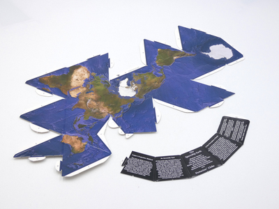
Description
Three maps with accompanying bases. Text on base reads:
"The fold-up globe is based on R. Buckminster Fuller’s world map. Fuller created several world maps in his attempt to create a visually accurate flat rendition of a spherical globe. His final version was based on the icosahedron, a polyhedron with 20 equilateral faces. Fuller first published his icosahedral version of the map in 1954. This cloud-free satellite image that fold-up into a globe is based on his icosahedron world map.
All flat world map representations of a spherical globe contain some amount of distortion whether in shape, area, distance or direction measurements. On the well-known Mercator world map, Greenland appears to be three times its corresponding globe size and Antartica appears as a long thin white stripe along the bottom edge of the map. Even the popular Robinson Projection, now used in many schools, still contains a large amount of distortion with Greenland 60 percent larger that its corresponding globe size.
If a world map represents visually obvious distortions of our world, then our perceptions and presumptions become distorted.Every project must make certain compromises as information is transferred from a spherical globe to a flat surface. As early as 1927 R. Buckminster Fuller began to search for a develop an accurate 2-dimensional world map. The Fuller projection enables us to visualize the planet’s surface in a single view without visually obvious distortions in the shape and size of landmasses.”
Date
2002
Classification
Artist Model
Object Number
AM.0391
Box Number
01
Source
Gift of Thomas T.K. Zung
Dimensions
3 items; approximately 12.7 x 25.4 cm each (5 x 10 inches )
Materials
card stock
Keywords
Arthur Loeb Design Science Teaching Collection, 3D models, geometric models, cartographic materials, "Fuller projection" (cartography)